Earthquake Country, Geomorphography, and our Latest Podcast Episodes

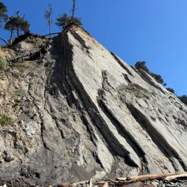
The northern-most San Andreas rift valley at Alder Creek in coastal Mendocino County is a highly fractured tectonic zone, featuring at least two main stems of the San Andreas Fault itself, and riddled with multiple minor transform and thrust faults, both on-land and offshore… Read More  Seismite: Sedimentary layers (lithified strata) deformed during the seismic … More Earthquake Country, Geomorphography, and our Latest Podcast Episodes

Biogeography of California’s Old Growth Canopy Mat Ecosystems

Within the oldest, tallest, and most isolated individuals among California’s totemic and scarce stands of old growth Coast redwood forest (Sequoia sempervirens), a shrouded and complex island ecosystem is supported high up in the monumental architecture of the inner canopy. Arboreal platform ecosystems structured and bioengineered by epiphytic plants, and buoyed by immense branching and … More Biogeography of California’s Old Growth Canopy Mat Ecosystems

Living Landscapes: Point Arena’s Sedimentary Complex, Tectonic Geomorphology, and Biogeographic Setting

Geography The Point Arena Terrane is a tectonic unit of geologic formations and sedimentary landforms west of the San Andreas Fault on the northern California coast, and is traveling northwestward along the transform plate boundary. The Point Arena peninsula, headlands, and coastal slope are a series of tectonic marine terraces, steadily and rapidly uplifting from … More Living Landscapes: Point Arena’s Sedimentary Complex, Tectonic Geomorphology, and Biogeographic Setting

California’s Coastal Prairies

California’s coastal prairies form a fragile and patchy network of long-lived, low profile, species-rich herbaceous ecosystems unique to the climate, geology and geography of California’s coastal regions. A steadfast and dominant biological component of the Pleistocene, coastal prairies harbor keystone perennial grass species, along with a multitude of annual and perennial forbs and graminoids. Herbaceous … More California’s Coastal Prairies

Earthquake Country: The Cordelia and Green Valley Faults

Situated at the southeastern edge of the Northern Coast Range, where subduction complex abuts the Great Valley Sequence, two outlying strands of the broad San Andreas fracture zone cut a striking and majestic tectonic landscape. The picture perfect Cordelia fault, and its more significant fractious neighbor, the Green Valley fault, sculpt plunging walls and scarps, … More Earthquake Country: The Cordelia and Green Valley Faults

Geomorphography: Bedform

Bedform defined: The transport of sand or gravel as bedload by currents and/or waves, creates a variety of geomorphic features on the bed, varying in size and form depending on complex interactions of the density, shape, and coarseness of the sediment particles; and on the depth, strength, uniformity and steadiness of the current. These features … More Geomorphography: Bedform

Wildfire in the Transverse Range Wildland Urban Interface

Spatial distribution of wildfires ignited under katabatic versus non-katabatic winds in Mediterranean southern California USA Santa Ana Winds: A Descriptive Climatology, American Meteorological Society Extreme Wildfire Environments and Their Impacts Occurring with Offshore-Directed Winds across the Pacific Coast States Physical Geography of the Transverse and Peninsular Ranges of Southern California The California Chaparral Institute: Too … More Wildfire in the Transverse Range Wildland Urban Interface

Creepy Fault Creep on the Maacama, Halloween Edition

The Maacama fault forms linear northwest trending transtensional basins in central Sonoma and Mendocino Counties, which contain many of the major towns in these counties, including Hopland, Ukiah, and Willits. Tell-tale evidence of fault creep can be traced throughout the town of Willits along the northwest trending slice of the Maacama fault where it cuts … More Creepy Fault Creep on the Maacama, Halloween Edition