Mendocino Triple Junction Parts 1 and 2: Tectonics, Evolution, and Structure
Mother Earth has made it clear that it’s time to talk about the Mendocino Triple Junction.
On December 5th, 2024 the most seismically active region in California had its largest earthquake in 20 years*: a magnitude 7.0 along the Mendocino Fracture Zone, approximately 35 miles offshore of Cape Mendocino, at a depth of 10 km/6.2 mi beneath the ocean floor. Fault rupture and tectonic release occurred as a result of right lateral strike slip motion conveyed by the eastward movement of the subducting Gorda Plate relative to the north-westward motion of the Pacific Plate.

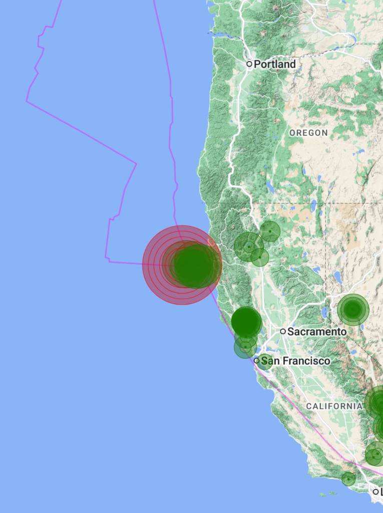
As far as aftershocks go, on December 8th, 2024 the USGS identified the 7.0 quake as the “potential” mainshock of a 319-event earthquake sequence.. and counting. A notable 4.3 magnitude earthquake, and possible aftershock, occurred just three minutes after the mainshock on the Maacama Fault (a branch of the San Andreas fracture zone) 180 miles to the southeast in Lake County near Cobb; a seismically vulnerable region known for geothermal and magmatic activity. Although both earthquakes occurred along the same disjointed fault system, it remains a question if the Cobb earthquake was in fact triggered by the 7.0 mainshock off Cape Mendocino to the northwest.
The December 5th Mendocino Fracture Zone earthquake was large enough to offset mass and energy through the Mendocino Triple Junction and redistribute it as pressure build-up along the northern San Andreas Fault, and the southern Cascadia megathrust subduction zone, increasing the likelihood of tectonic failure and seismic release along these major branching fault lines in the future.

What is the Mendocino Triple Junction
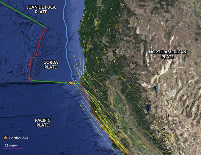
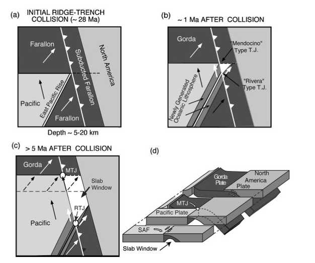
The Mendocino Triple Junction marks the convergence point of the Pacific, North American, and Gorda tectonic plates offshore of the Northern California coast.
The Gorda Plate to the north (conjoined with the Juan de Fuca Plate together represents the northern remnant of the ancient subducting Farallon Plate) converges with and subducts beneath the North American Plate to the east, at the Cascadia Subduction Zone.
While the Pacific and North American Plate boundary (San Andreas Fault) grinds along in right lateral motion as the two plates both drift westward: the Pacific to the northwest, and the North American to the southwest.
The collision of the Pacific and Gorda Plates also results in a right lateral transform boundary, known as the Mendocino Fracture Zone, which further compresses the Gorda into the North American Plate.
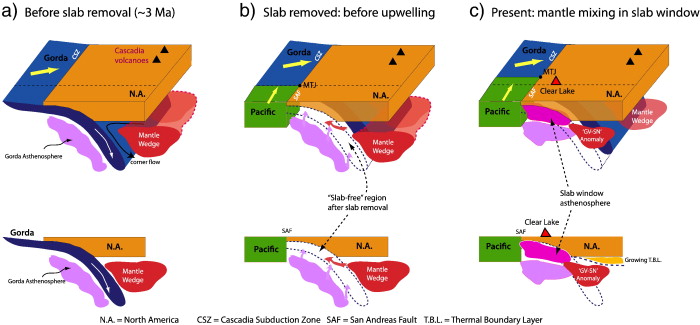
What is the Slab Window
With the complex motion of these massive tectonic plates, the Triple Junction migrates northward and the San Andreas fracture zone/plate boundary lengthens northward behind it.
As the Pacific Plate and the Triple Junction overtake the subducting Gorda Plate, the edge of the lithospheric slab of the subducted plate is severed and absorbs within the mantle. This forms a gap, or slab window, beneath the thinned lithosphere of the northeastern corner of the Pacific plate, and is occupied by upwelled asthenospheric material.
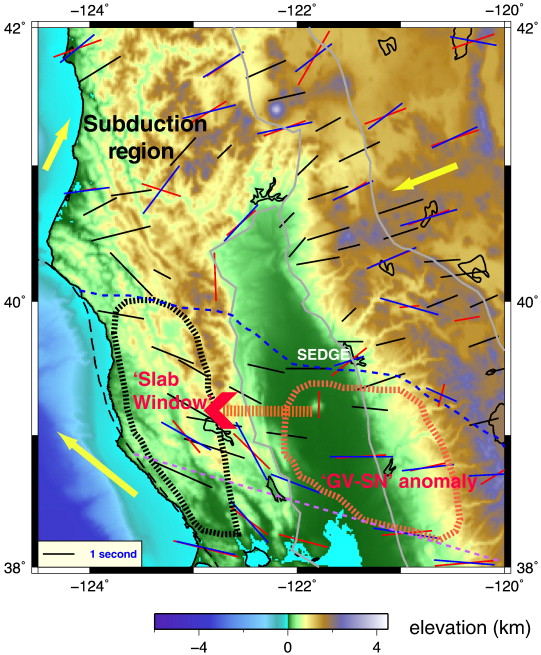
This slab window provides a region of active magmatic and geothermal activity to the southeast of the Mendocino Triple Junction, and trails along behind it on the northern migration. The epicenter of the December 5th 4.3 Lake County earthquake discussed above, was located within this slab window region.

What is the Mendocino Crustal Conveyor
The progressive crustal squeeze at the Mendocino Triple Junction, the subduction of the Gorda plate, and the formation of the slab window generates a conveyance of upwelled asthenospheric material adhering to and thickening the crust beneath the southern Gorda plate, while thinning the lithosphere above the slab window to the southeast. This conveyor mechanism, or process, migrates from south to north with the triple junction.
The dynamics of the slab window and the Mendocino Crustal Conveyor cause tectonic activity such as uplift of the earth’s crust, crustal deformation, seismicity, heat conveyance, gravitational anomalies, and magmatism.
As the migrating, upwelling, and uplifting crust initially thickens and then thins spatially and temporally from north to south, a telltale double-humped geomorphology of the Coast Range develops. It is proposed that this double humped Mendocino Crustal Conveyor topographic expression can be seen in the Coast Range between the Russian and Eel River drainages, and again between the Eel and the Van Duzen River drainages to the north.

As the Mendocino Triple Junction migrates northward, the upwelling, tectonics, uplift, and ultimately subsidence of the Mendocino Crustal Conveyor landforms, migrates with it.

What is the Pioneer Fragment
Approximately 30 million years ago as the Cenozoic-Mesozoic era subduction of the Farallon Plate and Pacific-Farallon Ridge drew to a close, the leading edge of the translating Pacific plate made contact with North America and the Pioneer Triple Junction was formed at this new point of contact between the Farallon, Pacific, and North American plates.
As the newly formed San Andreas transform plate boundary moved and extended laterally toward the northwest, the next leading edge of the Pacific Plate made contact with North America approximately 10-15 million years later to the north of the Pioneer Triple Junction. This new point of juncture formed the Mendocino Triple Junction, freezing the Pioneer Triple Junction, and capturing a fragment of the subducting Farallon Plate between the two. This is the Pioneer Fragment, a partially subducted block of Farallon lithosphere, now being transported along with the northwest- migrating Mendocino Triple Junction and transform plate boundary.
The Pioneer Fragment currently lays +/- 20 km below the earth’s surface, and occupies/overlays the western half of the slab window region. From the Mendocino triple junction the Pioneer Fragment extends southward approximately 150 miles to the latitude of the Pioneer Fracture Zone’s intersection with the coast (latitude 38.28872952°), which demarcates the location of the extinct Pioneer Triple Junction; and it extends approximately 65 miles eastward. The spatial relationship of the migrating Pioneer Fragment to the upwelling asthenosphere of the slab window propagates a shear zone at the fragment’s eastern edge, which develops into a deeper, sub-crustal primary tectonic plate boundary. The Maacama and its associated faults form the current, primary Pacific/North American Plate boundary at the eastern boundary of the Pioneer Fragment.

What is the Pioneer Corridor
As the Pioneer Fragment migrates northward with the Mendocino Triple Junction, a tectonic and geomorphic path, or corridor is emplaced along its trail. The Pioneer Fragment has left behind the Pioneer Corridor: a geomorphic and geologically distinct block of Franciscan Formation, which (in contrast to the highly deformed and uplifted corridor of the Mendocino Crustal Conveyor and slab window) displays repressed crustal deformation and limited uplift attributed to the dense and rigid lithospheric fragment traveling beneath the crust along the coastal region from south to north.
In the wake of the Pioneer Fragment and resulting corridor, the geologic Coastal Belt evolved as a less complex, less metamorphosed body of the Franciscan Formation, than the neighboring Central Belt of the Mendocino Crustal Conveyor/slab window corridor. Both the Pioneer Corridor and the geologic Coastal Belt are bound by the San Andreas Fault to the west and the Maacama Fault to the east in Northern California.

What is the Coastal Belt
The Coastal Belt is the westernmost and youngest of the three belts of Franciscan Complex that make up the northern Coast Range, and formed as the accretionary wedge prism of theFarallon-North American Plate subduction zone. The neighboring Central Belt to the east, and geologically delineated from the Coastal Belt at the Coastal Belt Thrust fault (directly adjacent to and at points intersecting with the transform Maacama fracture zone region), is composed of older, varied Franciscan assemblages and mélange formations. The narrow Eastern Belt, which lies to the east of the Central Belt and borders the Great Valley geologic backstop, contains the oldest and highest grade metamorphic lithology of the accretionary complex.
While the Coastal Belt is recognized as the youngest (Eocene aged), least metamorphosed, and least geologically rich body of the Franciscan Complex, it has also been understudied in contrast to the Central and Eastern Belts. Recognized as a uniform landscape comprised primarily of Arkosic Greywacke, metamorphosed Greywacke, and shale, recent findings show regularly spaced magnetic anomalies throughout the Coastal Belt, indicating especially steady and rapid uplift of the crust. This is also expressed in the vast, planar, uplifted landscape of marine terrace flights, ubiquitous along the western extent of the Coastal Belt.
*7.1 earthquake offshore along the Mendocino Fracture Zone in 1994, and a 7.2 onshore near Petrolia on an associated reverse fault in 1992
Resources
Furlong, K.P., et al. 1999. “Ephemeral crustal thickening at a triple junction: The Mendocino crustal conveyor.” Geology 27:127-130
Furlong, K., et al. 2004.”Influence of the Mendocino Triple Junction on the Tectonics of Coastal California.” Annual Review of Earth and Planetary Sciences 21(32):403-33
Furlong, K. P., et al. 2024. “Formation and evolution of the Pacific‐North American (San Andreas) plate boundary:Constraints from the crustal architecture of northern California.” Tectonics 43:1-23
Langenheim, V.E., et al. 2013. “Previously unrecognized regional structure of the Coastal Belt of the Franciscan Complex, northern California, revealed by magnetic data.” Geosphere 9(6):1514-1529
Lock, J., et al. 2006. “Late Neogene and Quaternary landscape evolution of the northernCalifornia Coast Ranges: Evidence for Mendocino triple junction tectonics.” GSA Bulletin 118:1232-1246
Peng, Y., et al.2017. “Geodetic constraint on the motion of a slab window: Implication forthe Mendocino Crustal Conveyor model.” Geophysical Research 44:7187–7193
Discover more from Cal Geographic
Subscribe to get the latest posts sent to your email.
