Geography
The Point Arena Terrane is a tectonic unit of geologic formations and sedimentary landforms west of the San Andreas Fault on the northern California coast, and is traveling northwestward along the transform plate boundary.
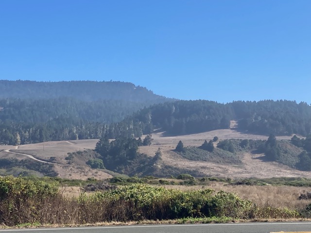
The Point Arena peninsula, headlands, and coastal slope are a series of tectonic marine terraces, steadily and rapidly uplifting from the waves, revealing progressively older sea level high stands of the Pleistocene as they ascend eastward.
Geology and Geomorphology
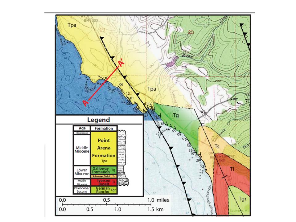
The Point Arena Terrane is composed primarily of sedimentary geologic units of the Miocene, including the Point Arena Formation (~11-16 ma), and overlays granitic basement rock of the much older Mesozoic Salinian Block.

The Point Arena Formation is constructed of sandstones and mudstones, including clay shales, fossiliferous sediments, and petroleum-bearing beds within the bituminous sandstones and mudstones. Additional sedimentary formations within and adjacent to the Point Arena Terrane include the Galloway Formation, and the Skooner/Schooner Gulch Formation, both from the early Miocene (~23-16 ma)
Within this landscape are a series of Cenozoic sedimentary basins, related to a pattern of recurring coastal depositional landforms spanning much of the California coast west of the San Andreas Fault. The Point Arena Basin (and adjoining Gualala Basin) is thought to be at the northern extent of this chain of uplifted marine sedimentary landforms.
The Point Arena Basin in particular, is believed to have been formed in the late Oligocene, approximately 24 million years ago, just two to four million years after the formation of the San Andreas Fault transform plate boundary.


California’s Cenozoic (and possibly late Cretaceous through Tertiary-aged) marine basins originated as depositional features within subsiding marine embayments or forearc basins at the later stages of subduction of the Farallon plate and throughout the transition of subduction to translation of the plate boundary, which uplifted and preserved these fragments.
Studies have revealed that the Point Arena Basin has experienced two major periods of deformation in the Miocene and Pliocene. One occurred approximately 15 million years ago due plate movements at the Mendocino Triple Junction, which created anticlinal features within the southern extent of the Basin; and the other is believed to have occurred approximately 3-4 million years ago due to a change in motion between the Pacific and North American plates, and resulted in folding as well as the development of a shear zone deep within the Basin.

San Andreas Fault Tectonics
Formed, isolated, and transported by the San Andreas Fault, Point Arena is the definition of a Tectonostratigraphic terrane. The proximity of the major plate boundary defines the current geology and geomorphology of the region, and informs local seismicity.
The rural northern landward extent of the San Andreas fault line is concealed in a remote and precipitously forested rift valley within rugged western ridges of the coast range, a few miles east of Point Arena. It forms most of the arrow-straight Gualala and Garcia River valleys, then extending northwestward from the western bend in the Garcia, in a string of tectonic pressure ridges and creek beds, finally exiting exposed land back under the Pacific Ocean at the north end of Manchester Beach as the Alder Creek drainage.

The major geomorphic feature of the San Andreas rift valley at Point Arena is actually a highly fractured tectonic zone, featuring at least two main stems of the San Andreas Fault itself, and riddled with multiple minor transform and thrust faults, both landward and offshore.
At this tectonically active region, field studies and ongoing monitoring of fault activity have revealed prehistoric earthquake intervals along the San Andreas, with the Garcia River as an ideal laboratory.


Prehistoric alluvial fan deposits on the Garcia River channel within the San Andreas Fault preserve the record of five great earthquakes within a 2000+ year period. With the fan aged to 2300-2700 years old, and tectonic offset of the channel measured at approximately 65 meters, a maximum slip rate of 25 mm/yr could be calculated, and an average rate of great earthquake occurrence calculated to between 200 and 400 year intervals along this strand of the fault.

Similarly, the major offsets and known ages of nearby marine terrace stands, which have been displaced by the San Andreas Fault, were utilized to calculate a slip rate of approximately 20mm/yr along this stretch of the San Andreas at the Garcia River channel.


Sedimentary Geomorphology and Features
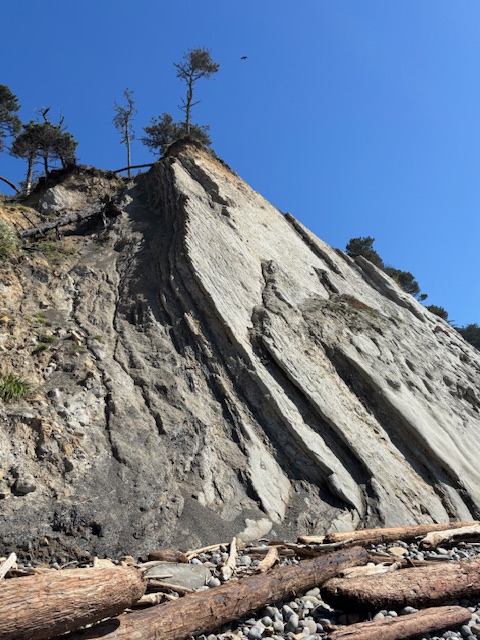
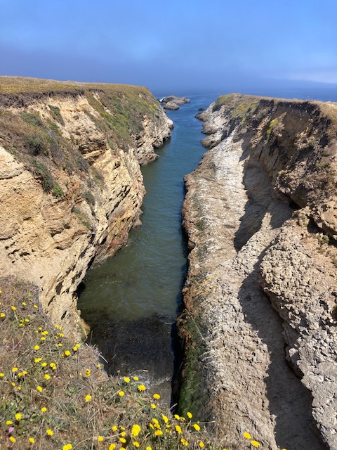
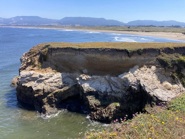
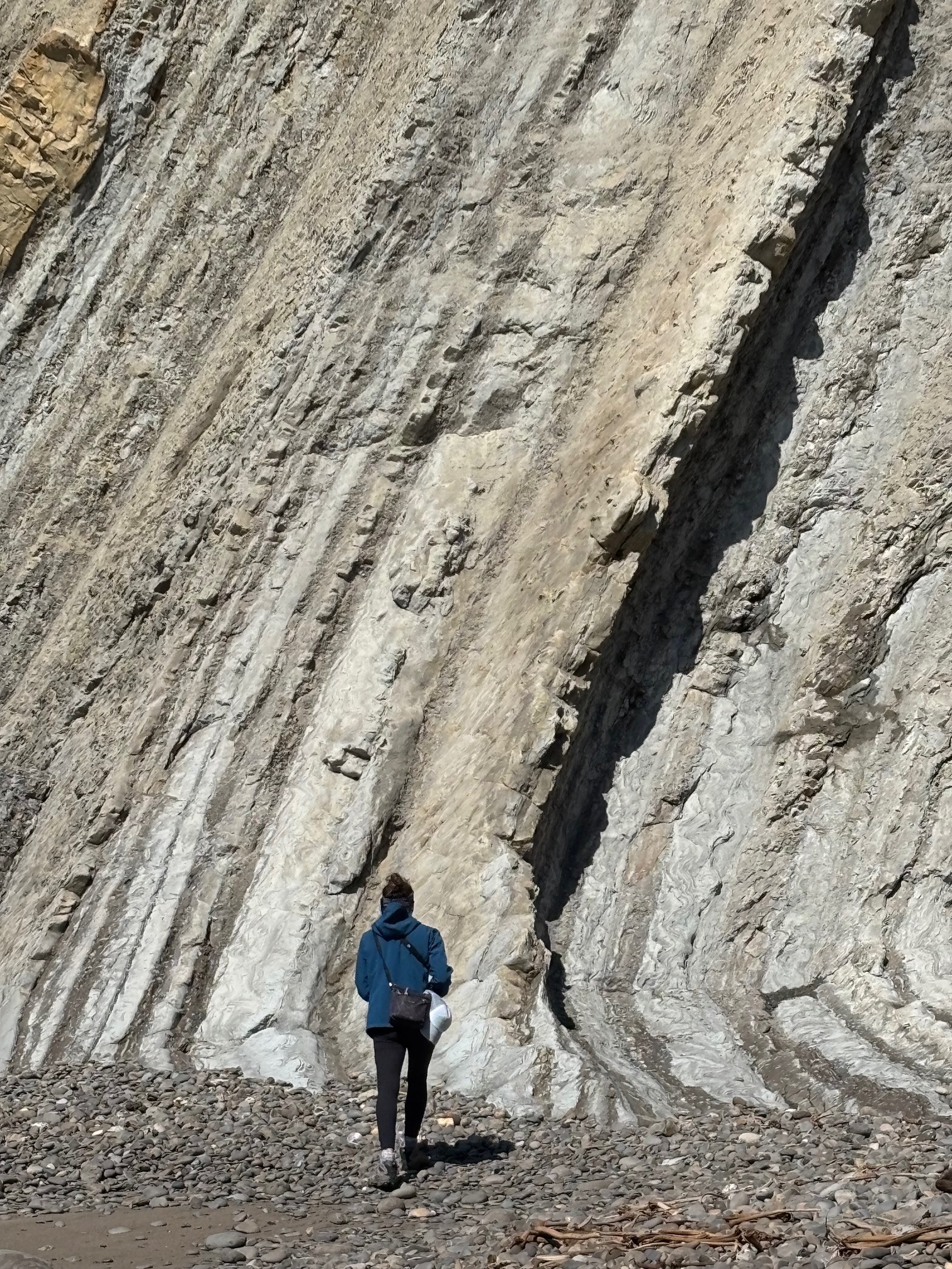
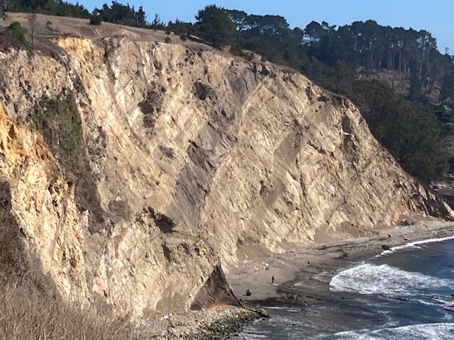
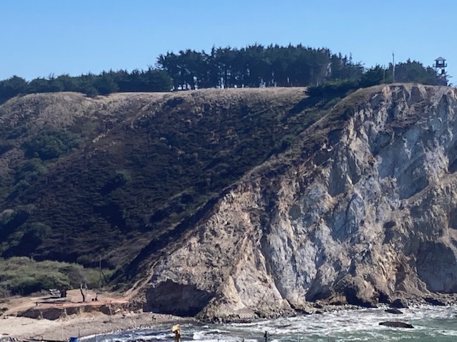
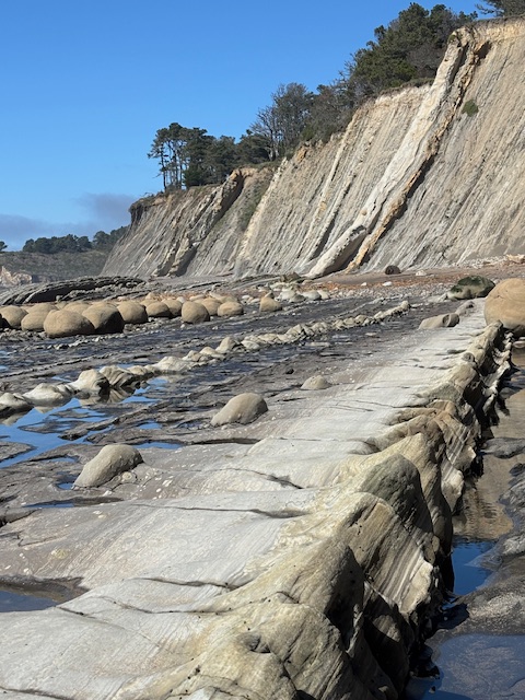
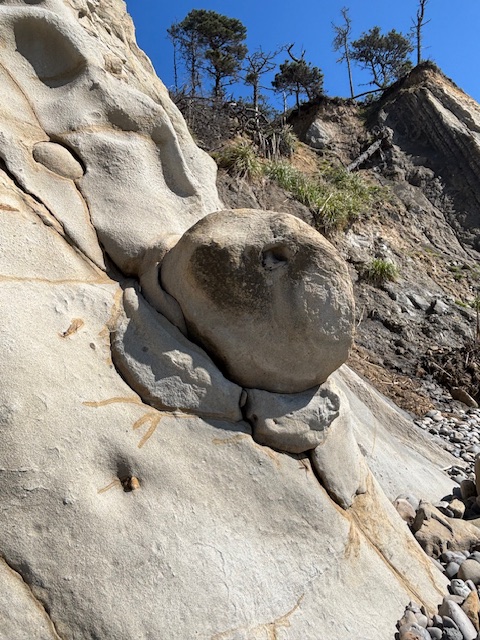
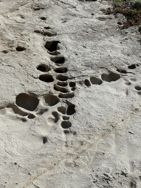
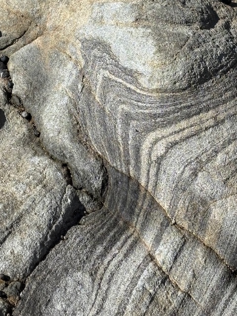
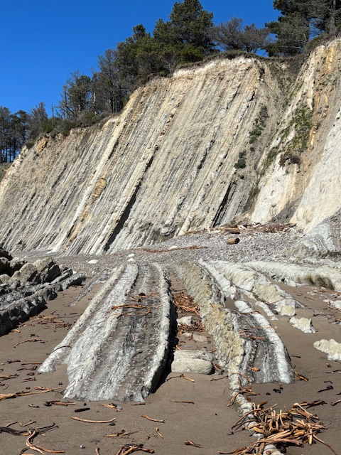
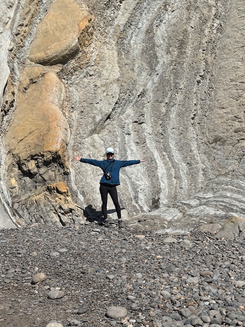
The highly erosional sedimentary formations of the Point Arena Terrane are visible as marine terrace cliff faces, reefs, ravines, and offshore rocks, with prominent bedding planes tilted, folded, and irregularly uplifted due to the active tectonics of the San Andreas fracture zone.
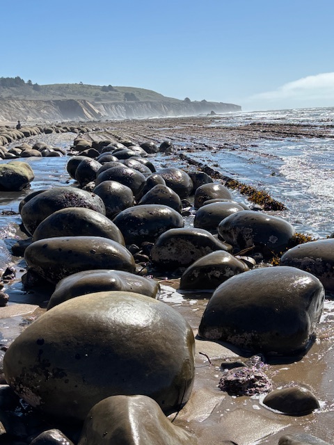

The strata of these geomorphic landforms reveal remarkable sedimentary signatures, such as waveform convolute laminations, sand dykes, trace fossils, veining, breccia, turbidites, and distinctly spherical concretions – some very large.


Geomorphology and Biogeography
Owing to its latitude, geology, soils, and tectonostratigraphic geomorphics, Point Arena represents the northern extent of Central California Pacific Plate ecotype-landscape. As a repeated landform system mirroring the Point Reyes Peninsula to its south, Point Arena is the northernmost outpost of exposed Salinian Block/Cenozoic Sedimentary complex uplifted west of the San Andreas Fault, and the associated ecosystems that form to this geomorphology.
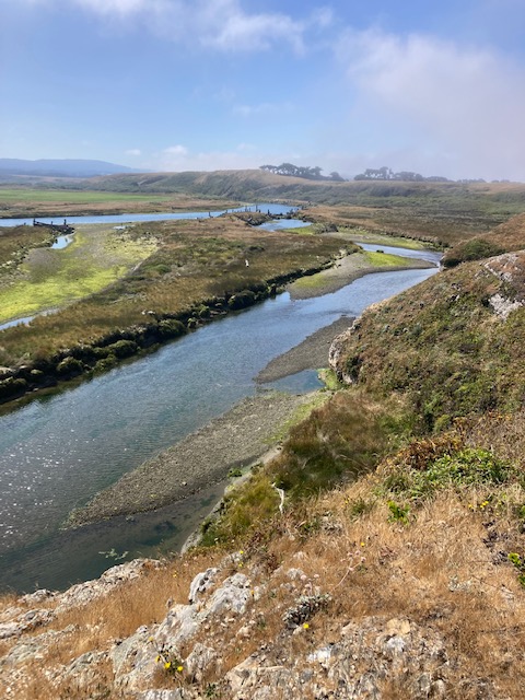


As with the Point Reyes Peninsula, Point Arena is fault-bounded to the east by the sharply linear San Andreas rift zone, and is flanked on the northwest by an extensive dissipative sandy beach, with a shoreface eroded and replenished by southward-dominated longshore drift. These tectonically influenced barrier shorelines are backed by a region of possible synclinal subsidence and lowland geomorphology, supporting extensive dune and wetland systems.


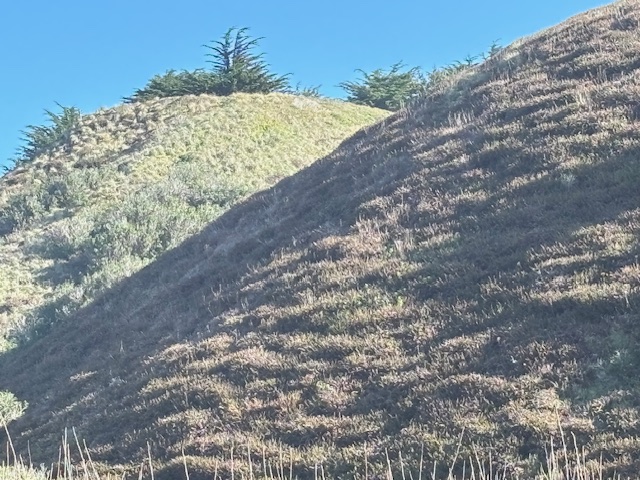
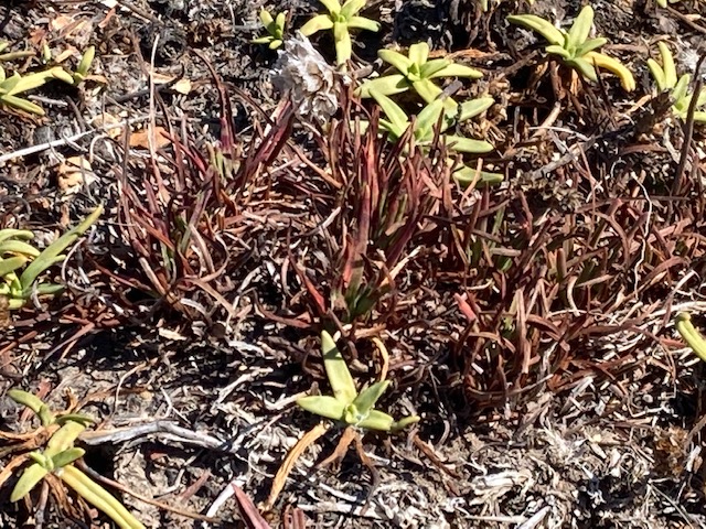
Point Arena’s sandstone and shale marine terraces are fog adapted and windswept, and host short stature floristic alliances and habitat types in the spectrum of the central coastal prairie, scrub and woodland mosaic. Generally, Point Arena’s native terrace habitats are dominated by Coastal Prairie, Northern Coastal Scrub types of several alliances, native Shore and Bishop pine woodlands, coastal wetland herbaceous alliance types, and coastal wetland/semi-riparian woodlands.

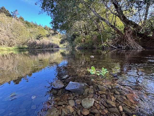
The Garcia River, which follows the San Andreas fault rift valley to the river’s dramatic westward bend east of Point Arena’s peninsula, hosts extensive tall Alder and Willow riparian woodlands, as well as varied stream bank, floodplain, freshwater marsh, and brackish marsh wetland alliances.

The California Native Plant Society Vegetation Program conducted extensive botanical surveys and data collection of detailed floristic communities and alliances (including assessment of non-native species and alliances) at the Point Arena Stornetta Lands National Monument, to produce the most up to date fine scale vegetation map and survey report, which is linked here.
Aplodontia
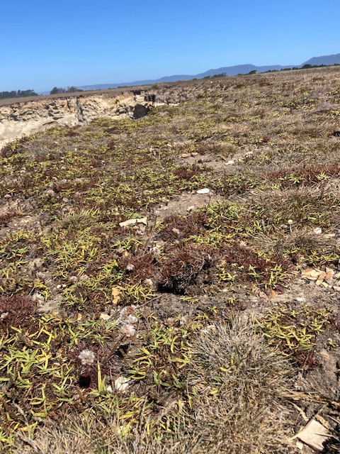
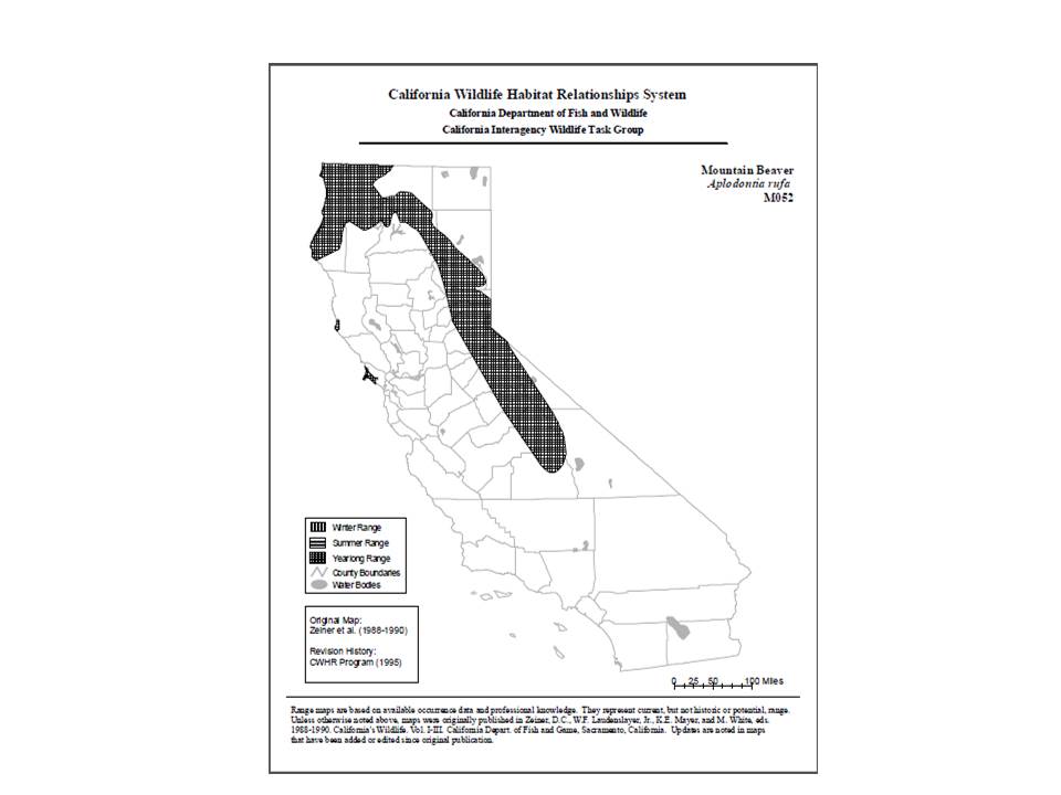
An intriguing and imperiled mammal species endemic to Point Arena, is the endangered Point Arena Mountain Beaver (Aplodontia rufa nigra). This mammal is not a beaver but is understood to be the most primitive rodent on earth, and is the only species of its family, Aplodontidae.

While misnamed, the Point Arena Mountain Beaver is not misunderstood. The Point Reyes Mountain Beaver (PAMB) has been the subject of scientific investigation and federal protection for over three decades, and was listed as an Endangered Species by the US Fish and Wildlife Service in 1991.
The Point Arena Mountain Beaver is one of seven subspecies spanning the west coast from Northern California (and the Sierra Nevada) up into southern British Columbia, and is an extreme genetic isolate population, along with the southern-most relict population, the Point Reyes Mountain Beaver (Aplodontia rufa phaea). The most recent assessment of population health and dynamics of PAMB appears to be the 2019 “Five Year Review of Point Arena Mountain Beaver (Aplodontia rufa nigra),” by the USFWS Arcata field office.
This is a compilation of field surveys, scientific studies, mapping projects, and literature reviews concerning PAMB. Unfortunately, it appears that field studies have been sporadic, with the most recent conducted in 2016. However, a large portion of the range of PAMB occurs on lands managed and protected by the US Bureau of Land Management, and the California State Parks. Concern remains high for populations on private lands around Point Arena, due to threats of residential development, agricultural practices, and industrial use such as logging, which is prevalent in the region.
According to the USFWS review, Point Arena Mountain Beavers do seem to occupy warmer and dryer climate niche’s than other subspecies of Aplodontia, but PAMB does select the coolest locations within the habitats of its range. Surveys of den selection sites within the Northern Coastal Scrub habitats of Point Arena, reveal PAMB favoring dense vegetation cover, as well as specific slope and aspect requirements.
Birthing season for PAMB young is believed to be in April, and based on noninvasive genetic sampling (hair snares) in the field, study results show populations at selected study sites holding steady and probably not declining, but concern remains for the very low numbers of the overall PAMB population. In addition, these field studies are over 15 years old.
In an investigation of how vegetation community type affects gene flow in PAMB, three geographic groups of low population size (due to historic genetic bottlenecks), were analyzed, and results show gene flow in PAMB was “best predicted” in forest habitats, with riparian habitats second, and agricultural lands the least favorable.
DNA data showed that two haplotype groups occurred in these regions, with one haplotype occurring north of the Garcia River, and both groups occurring south of the river, which indicates the river acts as a biogeographic barrier and “may have affected historical patterns of genetic divergence.”


References
Buck-Diaz, J. et al. 2020. “Vegetation Sampling, Mapping and Accuracy Assessment Report for Point Arena-Stornetta Unit.” California Native Plant Society, Vegetation Program
Forest, Rowena. 1987 to 2025: Field studies and research of California’s Living Landscapes; tectonostratigraphic geomorphics; Central California Pacific Plate ecotype-landscape; Salinian Block/Cenozoic Sedimentary complex uplifted west of the San Andreas Fault and associated geography and geomorphology; tectonically influenced northwest shorefacing dissipative sandy beach barriers eroded and replenished by southward-dominated longshore drift, backed by synclinal subsidence; sandstone and shale marine terrace floristic and wetland alliances. Cal Geographic
U.S. Fish and Wildlife Service’s Arcata Field Office (AFWO), 2019. “Five Year Review: Point Arena Mountain Beaver (Aplodontia rufa nigra)”
Grijalva, K. 2004. “Subsurface Study of Faults Near Point Arena and the San Andreas Fault Zone, Northern California, Using High-Resolution Reflection and Refraction Profiling.”
Gross, R. et al. 2002. “Shallow geometry and displacements on the San Andreas Fault near Point Arena based on trenching and 3-D georadar surveying.” Geophysical Research Letters 29(20)
Nilsen, T. et al. 1987. “Geological Evolution of the Late Cenozoic Basins of Northern Californis.” Symposium publication: Tectonics, Sedimentation, and Evolution of the Eel River and Associated Coastal Basins of Northern California – American Association of Petroleum Geologists.
Ondrus, A. 1997. “Deformation of the PointArena Basin and. the Location ofthe San Andreas Fault Zone, Offshore Northern California.” Thesis, Lehigh University
Prentice, C.S. 1989. “Earthquake Geology of the Northern San Andreas Fault Near Point Arena, California.” Dissertation, California Institute of Technology
Prentice, C. S. 1989. “Map of the terraces and other Quaternary deposits in the Point Arena area: Supplement 3 from Earthquake geology of the northern San Andreas fault near Point Arena, California” (Thesis)
Zachariasen, J. et al. 2008. “Final Technical Report Detailed Mapping of the Northern San Andreas Fault Using LiDAR Imagery.” USGS Western Region Earthquake Hazards Team
California Department of Conservation, Fault Activity Map
California Department of Conservation, Geologic Map of California
Discover more from Cal Geographic
Subscribe to get the latest posts sent to your email.
