Mass Movement:
The terms landslide and mass mass movement are often used interchangeably. However, mass movement is a designation encompassing numerous geomorphological processes including landslides. The general technical description for mass movement describes outward or descending gravitational movement of portions of a slope. More specifically, landslides are distinct mass movements that exhibit clear boundaries and have higher rates of movement than any movement on adjacent slopes.
There are numerous agents of mass movement across California’s landforms and landscapes, including geological, geomorphological, and human causes. These can include weathering or weakness of geologic material, tectonics, erosion, freeze-thaw processes, excavation, deforestation, drainage issues, and many more.
In the winter months the primary agent of earth movement in California is water. From the skies, precipitation causes mass movement induced by ground saturation, flooding, and overflows from blockage or damming on small and large scales. From the ocean, the marine erosional forces of wave and tidal action are major causes of coastal mass movement, cliff collapse, and bluff retreat.
The role of saturation excess threshold in mass movement:
Slope failure often occurs when moisture content of the soil reaches saturation, or close to saturation (positive pore pressure), reducing soil strength and causing loss of soil cohesion to the slope angle, and failure on the slip plane of the slide
The role of Liquefaction in mass movement:
Similar to an earthquake, the weight, energy and motion/vibration of slide material during a mass movement event can sometimes trigger rapid liquefaction of the soil bed as the slide occurs.
Liquefaction is described as a phenomenon in which the shear strength of a soil body is reduced due to increased pore water pressure when it is subjected to monotonic, cyclic, or constant volume dynamic loads.
(Further definition references are listed at the bottom of the Word of the Day home page)
Where in California:
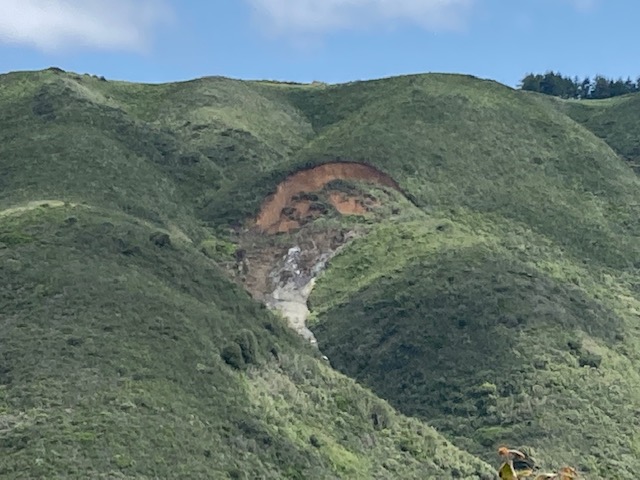
Two areas of particular geologic concern for mass movement in California are landforms and landscapes of the Franciscan Formation (Assemblage, Melange), and California’s coastal bluffs and cliffs.
At the leading edge of the North American tectonic plate, much of the Coast Ranges are comprised of the Franciscan Formation; a remnant of the Mesozoic subduction complex and accretionary wedge. Geologic units and materials of the Franciscan Formation are famously sheared, unconsolidated, and weak soils and rock – particularly our state rock, Serpentinite.
Central and southern coastal bluffs and cliff faces are often composed of younger, softer, friable sedimentary rocks and soils, such as shale/mudstone, and sandstones of the Cenozoic Era. Marine or coastal bluff erosion and retreat is pronounced along coastlines of the younger Pacific Plate, which stretches from Pacifica in San Mateo County, south to the Mexican border; and in patches from the Marin Coast to Point Arena in the north.
Two impressive prehistoric mass wasting events of note in California occurred along the central coast in today’s Marin County, on either side of the San Andreas Fault:
In the area of Double Point on the Point Reyes Peninsula a mega prehistoric landslide caused mass wasting of 10 square miles of highly fractured and crumbly Monterey shale along the Pacific plate coast, burying and dividing a contiguous marine terrace, and creating a rumpled, down-dropped landscape of steep rolling slopes cradling an unusual network of small lakes. In historic times indigenous communities and agricultural settlers took advantage of this locally rare perennial lacustrine resource. Today, hikers frequent these features now known as Bass Lake, Pelican Lake, Alamere Falls, and others at southwestern strip of Point Reyes National Seashore.
Another nearby prehistoric mega landslide of note is at the site of Slide Ranch on the coast of the North American plate along Highway One in southwestern Marin County. This rugged stretch of the Coast Range typifies California’s Franciscan Subduction Complex landscape of precipitous crumbling blue-green serpentinite and mélange geology. True to its name, the area suffers frequent landslides. One such prehistoric collapse opened up a towering bowl in the hillside, anchored by a gently sloping landslide debris pile, or toe, of pulverized serpentinite which now supports coastal prairie, sage scrublands, perennial springs, and more recently farmland and human habitation.
